

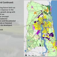
"The student avatar in the blue shirt stood in a virtual classroom, flanked by faculty and fellow student avatars. He focused a red laser simulator at a digital map of Lee County, Florida, pointing out where land could be developed near mass transit and urban services in order to reduce development in areas that may be better suited to agriculture. "Don't take anybody's eye out now," joked a faculty avatar."
Esri published a great article in ArcWatch on our program, with nice details and visual examples from our online studio course. Click here to read more about the program and hear how students tackled climate change issues using the geodesign framework and innovative software.